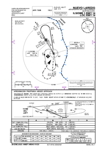


MMNL - Nuevo Laredo Quetzalcoatl
Located in Nuevo Laredo, Mexico
ICAO - MMNL, IATA - NLD
Data provided by AirmateGeneral information
Coordinates: N27°26'36" W99°34'12"
Elevation is 484 feet MSL.
View others Airports in Tamaulipas
Operational data
Special qualification required
Current time UTC:
Current local time:
Weather
METAR: MMNL 151440Z 16015KT 6SM SKC 28/23 A2980 RMK SLP072 57002 976 HZY
TAF: TAF MMNL 150531Z 1506/1606 15008KT P6SM SKC TEMPO 1510/1514 5SM HZ BKN020 FM151500 15012KT P6SM SCT100 SCT200 BECMG 1519/1521 12015KT FM160300 15010KT 6SM HZ BKN020 BKN200 PROB30 1602/1606 2SM TSRA BKN010CB
Communications frequencies: [VIEW]
Runways:
| RWY identifier | QFU | Length (ft) | Width (ft) | Surface | LDA (ft) |
| 14 | 151° | 6562 | 148 | ASP | |
| 32 | 331° | 6562 | 148 | ASP |
Airport contact information
Address: Nuevo Laredo Mexico