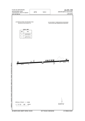


MMJA - Lencero
Located in Jalapa, Mexico
ICAO - MMJA, IATA - JAL
Data provided by AirmateGeneral information
Coordinates: N19°28'30" W96°47'51"
Elevation is 3136 feet MSL.
View others Airports in Veracruz
Operational data
Special qualification required
Current time UTC:
Current local time:
Weather at : MMVR - Veracruz Aeropuerto Internacional General Heriberto Jara ( 74 km )
METAR: MMVR 161450Z 18010KT 5SM SKC 31/24 A2971 RMK SLP037 52007 986 HZY
TAF: TAF MMVR 160515Z 1606/1706 18005KT 5SM HZ SCT100 TX33/1621Z TN24/1613Z TEMPO 1610/1614 2SM HZ SCT015 FM161500 15010KT 4SM HZ SKC FM161800 12010KT 5SM HZ SCT020 FM170000 09010KT 5SM HZ SCT020
Communications frequencies: [VIEW]
Runways:
| RWY identifier | QFU | Length (ft) | Width (ft) | Surface | LDA (ft) |
| 08 | 86° | 5577 | 98 | ASP | |
| 26 | 266° | 5577 | 98 | ASP |
Airport contact information
Address: Jalapa Mexico