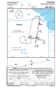
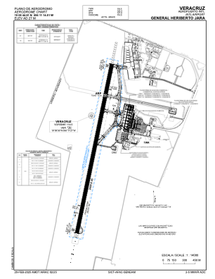


MMVR - Veracruz Aeropuerto Internacional General Heriberto Jara
Located in Veracruz, Mexico
ICAO - MMVR, IATA - VER
Data provided by AirmateGeneral information
Coordinates: N19°8'45" W96°11'15"
Elevation is 90 feet MSL.
View others Airports in Veracruz
Operational data
Special qualification required
Current time UTC:
Current local time:
Weather
METAR: MMVR 081843Z 15010KT 4SM SCT250 40/23 A2957 RMK 8/001 HZ
TAF: TAF MMVR 081729Z 0818/0918 17010KT 4SM HZ SCT250 TX38/0820Z TN25/0912Z FM082100 09015KT 5SM HZ SCT250 FM090300 36005KT 5SM HZ SCT250 FM091200 15005KT 4SM HZ SCT250
Communications frequencies: [VIEW]
Runways:
| RWY identifier | QFU | Length (ft) | Width (ft) | Surface | LDA (ft) |
| 01 | 11° | 7874 | 148 | UNK | |
| 19 | 191° | 7874 | 148 | UNK |
Airport contact information
Address: Veracruz Mexico