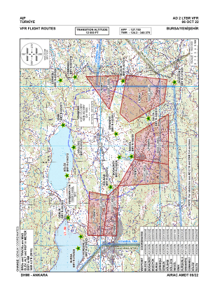
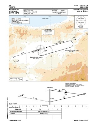


LTBR - Bursa Yenisehir
Located in Bursa/Yenisehir, Turkey
ICAO - LTBR, IATA - YEI
Data provided by AirmateGeneral information
Coordinates: N40°15'22" E29°33'43"
Elevation is 763 feet MSL.
Magnetic variation is 5.3° East View others Airports in Bursa
Operational data
Special qualification required
Current time UTC:
Current local time:
Weather
METAR: LTBR 150520Z VRB01KT CAVOK 10/04 Q1018 NOSIG RMK RWY07 VRB01KT
TAF: TAF LTBR 150440Z 1506/1606 VRB02KT CAVOK BECMG 1507/1511 36012KT FEW035 SCT100 BECMG 1515/1518 VRB02KT CAVOK
Communications frequencies: [VIEW]
Runways:
| RWY identifier | QFU | Length (ft) | Width (ft) | Surface | LDA (ft) |
| 07L | 75° | 9820 | 148 | CONC | 9820 |
| 25R | 255° | 9820 | 148 | CONC | 9820 |
| 07R | 75° | 9820 | 98 | CONC | 9820 |
| 25L | 255° | 9820 | 98 | CONC | 9820 |
Airport contact information
Address: Bursa/Yenisehir Turkey