


LJPOD - Podpec
Located in Podpe, Slovenia
ICAO - , IATA -
Data provided by AirmateGeneral information
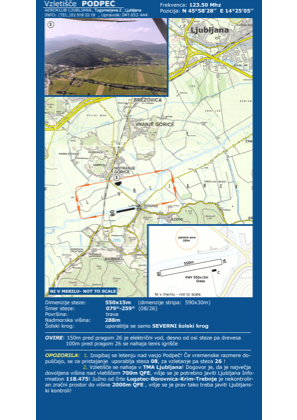
Coordinates: N45°58'28" E14°25'5"
Elevation is 944 feet MSL.
Magnetic variation is 4° East View others Airports in Ljubljana
Operational data
Special qualification required
Current time UTC:
Current local time:
Weather at : LJLJ - Ljubljana/Brnik ( 28 km )
METAR: LJLJ 181700Z 25004KT 210V290 9999 FEW050 22/07 Q1012 NOSIG
TAF: TAF LJLJ 181700Z 1818/1918 VRB02KT 9999 FEW050 PROB30 TEMPO 1913/1916 14010KT -SHRA SCT045TCU
Communications frequencies: [VIEW]
Runways:
| RWY identifier | QFU | Length (ft) | Width (ft) | Surface | LDA (ft) |
| 25 | 258° | 1642 | 66 | GRAS | |
| 07 | 78° | 1642 | 66 | GRAS |
Airport contact information
Address: Podpe Slovenia