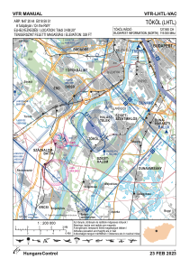


LHTL - Tokol
Located in Tokol, Hungary
ICAO - LHTL, IATA -
Data provided by AirmateGeneral information
Coordinates: N47°20'44" E18°58'51"
Elevation is 328 feet MSL.
View others Airports in Pest
Operational data
Special qualification required
Current time UTC:
Current local time:
Weather at : LHBP - Budapest/Liszt Ferenc International Airport ( 24 km )
METAR: LHBP 110530Z 08004KT 040V130 CAVOK 16/06 Q1020 NOSIG
TAF: TAF LHBP 110515Z 1106/1206 08008KT CAVOK BECMG 1109/1112 34006KT TEMPO 1118/1124 VRB14G24KT 6000 SHRA SCT060TCU BKN080 BECMG 1200/1203 07008KT BKN040
Communications frequencies: [VIEW]
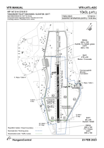
Runways:
| RWY identifier | QFU | Length (ft) | Width (ft) | Surface | LDA (ft) |
| 14 | 0° | 5118 | 197 | CONC | |
| 32 | 0° | 5118 | 197 | CONC | |
| 14R | 0° | 0 | 0 | UNK | |
| 32L | 0° | 0 | 0 | UNK |
Airport contact information
Address: Tokol Hungary