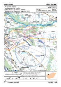
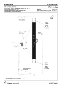


LHBY - Bony
Located in Bony, Hungary
ICAO - , IATA -
Data provided by AirmateGeneral information
Coordinates: N47°40'8" E17°47'5"
Elevation is 512 feet MSL.
View others Airports in Gyor-Moson-Sopron
Operational data
Special qualification required
Current time UTC:
Current local time:
Weather at : LHPR - Gyor/Per ( 5 km )
METAR: LHPR 252045Z AUTO 07006KT 040V110 CAVOK 16/14 Q1017
TAF: TAF LHPR 251715Z 2518/2603 VRB02KT CAVOK PROB40 TEMPO 2518/2601 VRB15G25KT 3500 TSRA SHRA SCT043CB BKN080 BECMG 2522/2601 10007KT PROB30 TEMPO 2601/2603 7000 -SHRA SCT050TCU BKN080
Communications frequencies: [VIEW]
Runways:
| RWY identifier | QFU | Length (ft) | Width (ft) | Surface | LDA (ft) |
| 13 | 0° | 2133 | 197 | GRASS | |
| 31 | 0° | 2133 | 197 | GRASS |
Airport contact information
Address: Bony Hungary