


LFYR - Romorantin Pruniers
Located in Romorantin, France
ICAO - LFYR, IATA -
Data provided by AirmateGeneral information
Coordinates: N47°19'15" E1°41'20"
Elevation is 289 feet MSL.
Magnetic variation is 0.91° East View others Airports in Centre
Operational data
Special qualification required
Current time UTC:
Current local time:
Weather
METAR: LFYR 162030Z AUTO 12001KT CAVOK 10/09 Q1008
TAF: TAF LFYR 161400Z 1615/1715 20005KT 9999 BKN010 TEMPO 1615/1621 4000 SHRA BKN040CB PROB40 TEMPO 1615/1618 VRB15G30KT 2000 TSRA SCT010 BKN030CB PROB30 TEMPO 1700/1706 3000 BR BKN003
Communications frequencies: [VIEW]
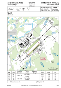
Runways:
| RWY identifier | QFU | Length (ft) | Width (ft) | Surface | LDA (ft) |
| 04L | 45° | 3609 | 328 | GRASS | |
| 22R | 225° | 3609 | 328 | GRASS | |
| 04R | 45° | 3117 | 328 | GRASS | |
| 22L | 225° | 3117 | 328 | GRASS |
Airport contact information
Address: Romorantin France

