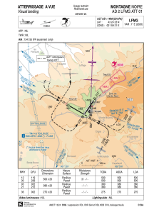


LFMG - Montagne Noire
Located in , France
ICAO - LFMG, IATA -
Data provided by AirmateGeneral information
Coordinates: N43°24'23" E1°59'21"
Elevation is 1468 feet MSL.
Magnetic variation is 1.13° East View others Airports in Languedoc-Roussillon
Operational data
Special qualification required
Current time UTC:
Current local time:
Weather at : LFCK - Castres Mazamet ( 29 km )
METAR: LFCK 211330Z AUTO 29013KT 260V320 9999 SCT043/// BKN050/// BKN066/// ///TCU 19/09 Q1014 TEMPO 4000 SHRA SCT025CB BKN040
Communications frequencies: [VIEW]
Runways:
| RWY identifier | QFU | Length (ft) | Width (ft) | Surface | LDA (ft) |
| 12 | 120° | 1640 | 66 | ASPH | 1640 |
| 30 | 300° | 1640 | 66 | ASPH | 1640 |
| 18 | 183° | 902 | 66 | ASPH | 902 |
| 36 | 3° | 902 | 66 | ASPH | 902 |
| 03 | 33° | 1247 | 66 | ASPH | 1247 |
| 21 | 213° | 1247 | 66 | ASPH | 1247 |
Airport contact information
Address: France