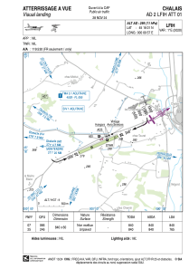


LFIH - Chalais
Located in Chalais, France
ICAO - LFIH, IATA -
Data provided by AirmateGeneral information
Coordinates: N45°16'1" E0°0'57"
Elevation is 299 feet MSL.
Magnetic variation is 0.52° East View others Airports in Poitou-Charentes
Operational data
Special qualification required
Current time UTC:
Current local time:
Weather at : LFBG - Cognac Chateaubernard ( 51 km )
METAR: LFBG 100300Z AUTO 07004KT CAVOK 12/10 Q1017
Communications frequencies: [VIEW]
Runways:
| RWY identifier | QFU | Length (ft) | Width (ft) | Surface | LDA (ft) |
| 07 | 67° | 2756 | 197 | GRASS | |
| 25 | 247° | 2756 | 197 | GRASS | 2510 |
Airport contact information
Address: Chalais France
Other aviation service providers
Aviation club (not for profit)

Aéroclub les Ailes Chalaisiennes
Aéroclub les Ailes Chalaisiennes
les.ailes.chalaisiennes@orange.fr+33545982834