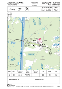


LFIB - Belves Saint Pardoux
Located in Belves, France
ICAO - LFIB, IATA -
Data provided by AirmateGeneral information
Coordinates: N44°46'53" E0°57'27"
Elevation is 791 feet MSL.
Magnetic variation is 0.81° East View others Airports in Aquitaine
Operational data
Special qualification required
Current time UTC:
Current local time:
Weather at : LFBE - Bergerac Dordogne Perigord ( 35 km )
METAR: LFBE 180800Z AUTO VRB02KT 9999 SCT008 OVC078 15/12 Q1013 NOSIG
TAF: TAF LFBE 180500Z 1806/1906 VRB03KT CAVOK PROB40 TEMPO 1806/1808 1500 -RADZ BKN005 TEMPO 1810/1818 4000 SHRA BKN030TCU PROB30 1813/1817 1500 -TSRA BKN030CB BECMG 1822/1824 3000 BR TEMPO 1900/1906 0500 FG VV///
Communications frequencies: [VIEW]
Runways:
| RWY identifier | QFU | Length (ft) | Width (ft) | Surface | LDA (ft) |
| 11 | 107° | 2625 | 197 | GRASS | 2034 |
| 29 | 287° | 2625 | 197 | GRASS | 2625 |
Airport contact information
Address: Belves France
