


LFFI - Ancenis
Located in Ancenis, France
ICAO - LFFI, IATA -
Data provided by AirmateGeneral information
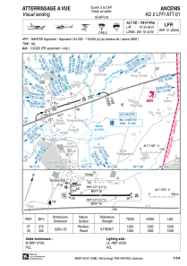
Coordinates: N47°24'26" W1°10'44"
Elevation is 109 feet MSL.
Magnetic variation is 0.03° East View others Airports in Pays-de-la-Loire
Operational data
Special qualification required
Current time UTC:
Current local time:
Weather at : LFRS - Nantes Atlantique ( 43 km )
METAR: LFRS 210900Z AUTO 33007KT 290V030 9999 BKN017 BKN030 BKN047 16/12 Q1009 TEMPO 4500 -SHRA BKN030CB
TAF: TAF LFRS 210500Z 2106/2212 33004KT 9999 SCT014 BKN065 TEMPO 2106/2109 BKN014 TEMPO 2109/2119 4500 -SHRA BKN030CB PROB40 TEMPO 2114/2118 VRB15G25KT 2500 TSRA PROB30 TEMPO 2200/2206 -SHRA SCT070TCU PROB40 TEMPO 2209/2212 2500 SHRA BKN030CB
Communications frequencies: [VIEW]
Runways:
| RWY identifier | QFU | Length (ft) | Width (ft) | Surface | LDA (ft) |
| 07 | 72° | 3937 | 82 | ASPH | 3937 |
| 25 | 252° | 3937 | 82 | ASPH | 3937 |
Airport contact information
Address: Ancenis France

