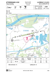


LFDR - La Reole Floudes
Located in La Reole, France
ICAO - LFDR, IATA -
Data provided by AirmateGeneral information
Coordinates: N44°34'1" W0°3'26"
Elevation is 44 feet MSL.
Magnetic variation is 0.54° East View others Airports in Aquitaine
Operational data
Special qualification required
Current time UTC:
Current local time:
Weather at : LFBE - Bergerac Dordogne Perigord ( 54 km )
METAR: LFBE 180000Z AUTO 07002KT CAVOK 11/11 Q1011 TEMPO 2000 BR BKN003
TAF: TAF LFBE 172300Z 1800/1824 VRB03KT CAVOK TEMPO 1800/1807 2000 BR BKN003 PROB40 TEMPO 1803/1806 0600 FG VV/// PROB30 TEMPO 1803/1806 1500 -RADZ BKN005 TEMPO 1810/1818 4000 SHRA BKN030TCU PROB30 1813/1817 1500 -TSRA BKN030CB
Communications frequencies: [VIEW]
Runways:
| RWY identifier | QFU | Length (ft) | Width (ft) | Surface | LDA (ft) |
| 08 | 78° | 3156 | 197 | GRASS | 3156 |
| 26 | 258° | 3156 | 197 | GRASS | 2552 |
Airport contact information
Address: La Reole France
