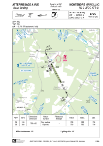


LFDC - Montendre Marcillac
Located in Montendre, France
ICAO - LFDC, IATA -
Data provided by AirmateGeneral information
Coordinates: N45°16'25" W0°27'12"
Elevation is 145 feet MSL.
Magnetic variation is 0.39° East View others Airports in Aquitaine
Operational data
Special qualification required
Current time UTC:
Current local time:
Weather at : LFBG - Cognac Chateaubernard ( 44 km )
METAR: LFBG 150100Z AUTO 19008KT 9999 NSC 11/10 Q1006
TAF: TAF LFBG 142000Z 1421/1521 22005KT CAVOK PROB30 TEMPO 1421/1503 4000 -SHRA BKN025TCU TEMPO 1506/1518 23015G25KT 4000 -SHRA BKN020CB
Communications frequencies: [VIEW]
Runways:
| RWY identifier | QFU | Length (ft) | Width (ft) | Surface | LDA (ft) |
| 15 | 153° | 2592 | 197 | GRASS | 2592 |
| 33 | 333° | 2592 | 197 | GRASS | 2592 |
Airport contact information
Address: Montendre France

