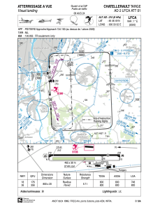


LFCA - Chatellerault Targe
Located in Chatellerault, France
ICAO - LFCA, IATA - XCX
Data provided by AirmateGeneral information
Coordinates: N46°46'49" E0°33'2"
Elevation is 210 feet MSL.
Magnetic variation is 0.60° East View others Airports in Poitou-Charentes
Operational data
Special qualification required
Current time UTC:
Current local time:
Weather at : LFBI - Poitiers Biard ( 28 km )
METAR: LFBI 111100Z AUTO VRB03KT CAVOK 25/13 Q1016 NOSIG
TAF: TAF LFBI 110500Z 1106/1206 02004KT CAVOK PROB30 TEMPO 1115/1119 4000 -TSRA SCT050CB BECMG 1123/1201 22012KT BECMG 1203/1205 31010KT TEMPO 1204/1206 4000 -SHRA SCT030TCU
Communications frequencies: [VIEW]
Runways:
| RWY identifier | QFU | Length (ft) | Width (ft) | Surface | LDA (ft) |
| 18 | 177° | 2625 | 66 | ASPH | 2454 |
| 36 | 357° | 2625 | 66 | ASPH | 2625 |
Airport contact information
Address: Chatellerault France
