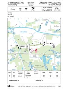


LFAL - La Fleche Thoree Les Pins
Located in , France
ICAO - LFAL, IATA -
Data provided by AirmateGeneral information
Coordinates: N47°41'34" W0°0'7"
Elevation is 120 feet MSL.
Magnetic variation is 0.38° East View others Airports in Pays-de-la-Loire
Operational data
Special qualification required
Current time UTC:
Current local time:
Weather at : LFJR - Angers Marce ( 28 km )
METAR: LFJR 302300Z AUTO 30004KT 240V340 9999 -RA BKN043 BKN050 BKN064 13/08 Q1009
Communications frequencies: [VIEW]
Runways:
| RWY identifier | QFU | Length (ft) | Width (ft) | Surface | LDA (ft) |
| 08 | 83° | 2625 | 164 | GRASS | 3724 |
| 26 | 263° | 2625 | 164 | GRASS | 4708 |
Airport contact information
Address: France

