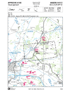
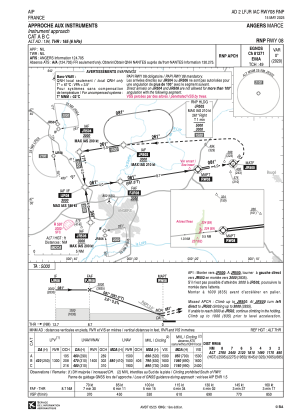
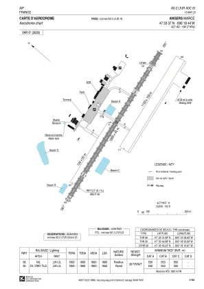


LFJR - Angers Marce
Located in Angers, France
ICAO - LFJR, IATA - ANE
Data provided by AirmateGeneral information
Coordinates: N47°33'37" W0°18'44"
Elevation is 194 feet MSL.
Magnetic variation is 0.29° East View others Airports in Pays-de-la-Loire
Operational data
Special qualification required
Current time UTC:
Current local time:
Weather
METAR: LFJR 281600Z AUTO 26008KT 220V320 9999 FEW001/// SCT039/// BKN056/// ///TCU 15/08 Q1013
Communications frequencies: [VIEW]
Runways:
| RWY identifier | QFU | Length (ft) | Width (ft) | Surface | LDA (ft) |
| 08R | 81° | 3609 | 328 | GRASS | 3609 |
| 26L | 261° | 3609 | 328 | GRASS | 3609 |
| 08L | 81° | 2362 | 164 | GRASS | 2362 |
| 26R | 261° | 2362 | 164 | GRASS | 1542 |
| 08 | 81° | 5906 | 148 | ASPH | 5906 |
| 26 | 261° | 5906 | 148 | ASPH | 5177 |
Airport contact information
Address: Angers France
Handlers

Other aviation service providers
Aviation club (not for profit)

Group. Preserv. Patri. Aéro. - GPPA
Group. Preserv. Patri. Aéro. - GPPA
info@musee-aviation-angers.fr+33241330410
