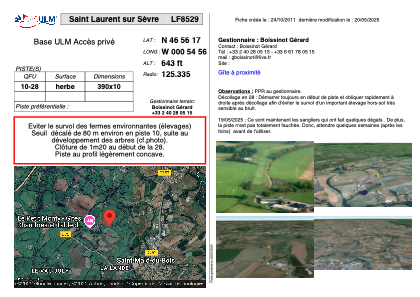


LF8529 - Saint Laurent sur Sèvre
Located in Saint-Laurent-sur-Sèvre , France
ICAO - , IATA -
Data provided by AirmateGeneral information
Coordinates: N46°56'17" W0°54'56"
Elevation is 643 feet MSL.
View others Airports in Poitou-Charentes
Operational data
Special qualification required
Current time UTC:
Current local time:
Weather at : LFRI - La Roche Sur Yon Les Ajoncs ( 44 km )
METAR: LFRI 131530Z AUTO 22008KT 190V250 9999 -RA NSC 15/12 Q1006 TEMPO 3000 RA OVC005
TAF: TAF LFRI 131100Z 1312/1412 18011KT 9999 BKN020 BECMG 1314/1317 -RA TEMPO 1317/1321 3000 RA OVC005 PROB40 TEMPO 1320/1322 2000 -RA OVC003 BECMG 1320/1322 24006KT NSW FM141000 22012KT 9999 BKN025 PROB40 TEMPO 1410/1412 24015G25KT
Communications frequencies: [VIEW]
Runways:
| RWY identifier | QFU | Length (ft) | Width (ft) | Surface | LDA (ft) |
| 10 | 0° | 1279 | 32 | GRASS | |
| 28 | 0° | 1279 | 32 | GRASS |
Airport contact information
Address: Saint-Laurent-sur-Sèvre France