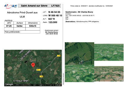


LF7925 - Saint Amand sur Sèvre
Located in Saint-Amand-sur-Sèvre, France
ICAO - , IATA -
Data provided by AirmateGeneral information
Coordinates: N46°54'5" W0°48'10"
Elevation is 607 feet MSL.
View others Airports in Poitou-Charentes
Operational data
Special qualification required
Current time UTC:
Current local time:
Weather at : LFRI - La Roche Sur Yon Les Ajoncs ( 49 km )
METAR: LFRI 130530Z AUTO 19006KT CAVOK 14/12 Q1012 NOSIG
TAF: TAF LFRI 130500Z 1306/1406 19008KT 9999 BKN020 BECMG 1313/1316 RA TEMPO 1318/1322 4000 -RA BKN005 BECMG 1319/1322 24006KT NSW
Communications frequencies: [VIEW]
Runways:
| RWY identifier | QFU | Length (ft) | Width (ft) | Surface | LDA (ft) |
| 07 | 0° | 1738 | 49 | GRASS | |
| 25 | 0° | 1738 | 49 | GRASS |
Airport contact information
Address: Saint-Amand-sur-Sèvre France