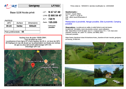


LF7033 - Gevigney
Located in Gevigney-et-Mercey, France
ICAO - , IATA -
Data provided by AirmateGeneral information
Coordinates: N47°47'49" E5°54'47"
Elevation is 720 feet MSL.
View others Airports in Franche-Comté
Operational data
Special qualification required
Current time UTC:
Current local time:
Weather at : LFSX - Luxeuil Saint Sauveur ( 34 km )
METAR: LFSX 232000Z AUTO 00000KT 9999 FEW025/// BKN033/// BKN041/// ///TCU 12/11 Q1018
TAF: TAF LFSX 231400Z 2315/2415 22003KT 9999 SCT030 TEMPO 2315/2318 4000 SHRA SCT020TCU PROB40 TEMPO 2315/2317 2000 TSRA SCT020CB BECMG 2323/2401 2000 BR BKN002 TEMPO 2401/2404 0900 FG VV/// BECMG 2404/2406 9999 NSW SCT015 TEMPO 2407/2415 4000 SHRA SCT015TCU PROB40 TEMPO 2411/2415 2000 TSRA SCT015CB
Communications frequencies: [VIEW]
Runways:
| RWY identifier | QFU | Length (ft) | Width (ft) | Surface | LDA (ft) |
| 05 | 0° | 1640 | 78 | GRASS | |
| 23 | 0° | 1640 | 78 | GRASS |
Airport contact information
Address: Gevigney-et-Mercey France