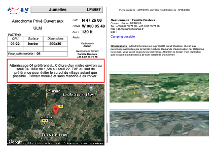


LF4957 - Jumelles
Located in Jumelles, France
ICAO - , IATA -
Data provided by AirmateGeneral information
Coordinates: N47°26'8" W0°5'48"
Elevation is 130 feet MSL.
View others Airports in Pays-de-la-Loire
Operational data
Special qualification required
Current time UTC:
Current local time:
Weather at : LFJR - Angers Marce ( 21 km )
METAR: LFJR 302100Z AUTO 12004KT CAVOK 11/09 Q1008
Communications frequencies: [VIEW]
Runways:
| RWY identifier | QFU | Length (ft) | Width (ft) | Surface | LDA (ft) |
| 04 | 0° | 1312 | 98 | GRASS | |
| 22 | 0° | 1312 | 98 | GRASS |
Airport contact information
Address: Jumelles France