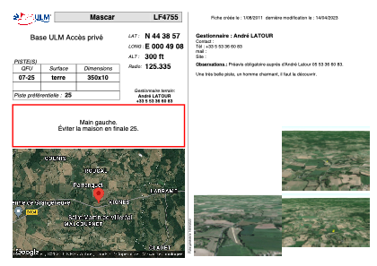


LF4755 - Mascar
Located in Saint-Martin-de-Villeréal, France
ICAO - , IATA -
Data provided by AirmateGeneral information
Coordinates: N44°38'57" E0°49'8"
Elevation is 300 feet MSL.
View others Airports in Aquitaine
Operational data
Special qualification required
Current time UTC:
Current local time:
Weather at : LFBE - Bergerac Dordogne Perigord ( 31 km )
METAR: LFBE 151830Z AUTO 22004KT 190V260 9999 FEW040/// SCT056/// ///TCU 16/12 Q1007 BECMG BKN020
TAF: TAF LFBE 151100Z 1512/1612 26010KT 9999 BKN020 TEMPO 1512/1518 3000 SHRA BKN010 BKN020TCU PROB30 TEMPO 1512/1516 23015G25KT 1200 TSRA BKN005 BKN015CB BECMG 1518/1520 20005KT BECMG 1523/1601 VRB02KT PROB40 1601/1606 4000 BR BECMG 1606/1608 18005KT TEMPO 1609/1612 4000 SHRA BKN030TCU
Communications frequencies: [VIEW]
Runways:
| RWY identifier | QFU | Length (ft) | Width (ft) | Surface | LDA (ft) |
| 07 | 0° | 1148 | 32 | DIRT | |
| 25 | 0° | 1148 | 32 | DIRT |
Airport contact information
Address: Saint-Martin-de-Villeréal France