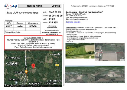


LF4453 - Nantes Héric
Located in Héric, France
ICAO - , IATA -
Data provided by AirmateGeneral information
Coordinates: N47°23'9" W1°38'8"
Elevation is 110 feet MSL.
View others Airports in Pays-de-la-Loire
Operational data
Special qualification required
Current time UTC:
Current local time:
Weather at : LFRS - Nantes Atlantique ( 26 km )
METAR: LFRS 211900Z AUTO 31006KT CAVOK 14/12 Q1012 TEMPO 4000 -SHRA BKN030CB
TAF: TAF LFRS 211700Z 2118/2224 33008KT 9999 BKN025 TEMPO 2118/2124 4000 -SHRA BKN030CB PROB30 TEMPO 2200/2206 -SHRA SCT070TCU BECMG 2121/2124 26008KT PROB40 TEMPO 2206/2216 2500 SHRA BKN030CB PROB30 TEMPO 2216/2224 4000 SHRA BKN030CB
Communications frequencies: [VIEW]
Runways:
| RWY identifier | QFU | Length (ft) | Width (ft) | Surface | LDA (ft) |
| 09 | 0° | 1049 | 98 | GRASS | |
| 27 | 0° | 1049 | 98 | GRASS |
Airport contact information
Address: Héric France