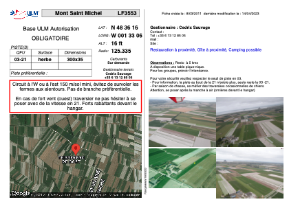


LF3553 - Mont Saint Michel
Located in Saint-Georges-de-Gréhaigne, France
ICAO - , IATA -
Data provided by AirmateGeneral information
Coordinates: N48°36'16" W1°33'6"
Elevation is 16 feet MSL.
View others Airports in Lower Normandy
Operational data
Special qualification required
Current time UTC:
Current local time:
Weather at : LFRD - Dinard Pleurtuit Saint Malo ( 39 km )
METAR: LFRD 162100Z AUTO 13005KT CAVOK 12/11 Q1005 NOSIG
TAF: TAF LFRD 161700Z 1618/1718 VRB05KT 9999 BKN020 TEMPO 1618/1620 3000 SHRA BKN020CB PROB40 TEMPO 1618/1619 1500 TSRAGS BKN012 BKN020CB TEMPO 1700/1707 3000 BR BKN005 PROB40 TEMPO 1702/1706 0500 FG VV/// TEMPO 1707/1709 BKN010 TEMPO 1709/1718 3000 SHRA BKN020CB PROB40 TEMPO 1713/1718 1500 TSRAGS BKN012 BKN020CB
Communications frequencies: [VIEW]
Runways:
| RWY identifier | QFU | Length (ft) | Width (ft) | Surface | LDA (ft) |
| 03 | 0° | 984 | 114 | GRASS | |
| 21 | 0° | 984 | 114 | GRASS |
Airport contact information
Address: Saint-Georges-de-Gréhaigne France