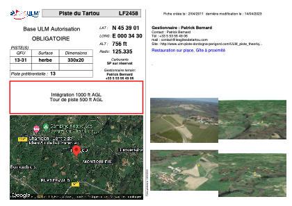


LF2458 - Piste du Tartou
Located in Tartou, France
ICAO - , IATA -
Data provided by AirmateGeneral information
Coordinates: N45°39'1" E0°34'30"
Elevation is 756 feet MSL.
View others Airports in Poitou-Charentes
Operational data
Special qualification required
Current time UTC:
Current local time:
Weather at : LFBU - Angouleme Brie Champniers ( 29 km )
METAR: LFBU 180430Z AUTO 00000KT 3800 BR NSC 09/08 Q1011
Communications frequencies: [VIEW]
Runways:
| RWY identifier | QFU | Length (ft) | Width (ft) | Surface | LDA (ft) |
| 13 | 0° | 1082 | 65 | GRASS | |
| 31 | 0° | 1082 | 65 | GRASS |
Airport contact information
Address: Tartou France