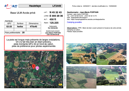


LF2449 - Hautefaye
Located in Hautefaye, France
ICAO - , IATA -
Data provided by AirmateGeneral information
Coordinates: N45°32'43" E0°29'36"
Elevation is 450 feet MSL.
View others Airports in Poitou-Charentes
Operational data
Special qualification required
Current time UTC:
Current local time:
Weather at : LFBU - Angouleme Brie Champniers ( 30 km )
METAR: LFBU 051130Z AUTO 16007KT 110V200 9999 FEW024 SCT052 OVC092 19/15 Q1009 TEMPO VRB15G25KT 1500 TSRAGS BKN010 BKN015CB
TAF: TAF LFBU 051100Z 0512/0612 20008KT 9999 BKN020 TEMPO 0512/0516 4000 -SHRA BKN020TCU PROB30 TEMPO 0512/0514 VRB20G30KT 1500 TSRAGS BKN010 BKN015CB PROB40 0520/0607 3000 RA BKN010 TEMPO 0607/0612 SHRA BKN015TCU
Communications frequencies: [VIEW]
Runways:
| RWY identifier | QFU | Length (ft) | Width (ft) | Surface | LDA (ft) |
| 02 | 0° | 1541 | 131 | GRASS | |
| 20 | 0° | 1541 | 131 | GRASS |
Airport contact information
Address: Hautefaye France