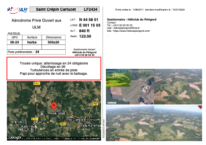


LF2434 - Saint Crépin Carlucet
Located in Saint-Crépin-et-Carlucet, France
ICAO - , IATA -
Data provided by AirmateGeneral information
Coordinates: N44°58'1" E1°15'3"
Elevation is 840 feet MSL.
View others Airports in Aquitaine
Operational data
Special qualification required
Current time UTC:
Current local time:
Weather at : LFSL - Brive Souillac ( 20 km )
METAR: LFSL 151030Z AUTO 20003KT 150V270 9999 NSC 13/09 Q1008 TEMPO 1200 TSRA BKN005 BKN020CB
TAF: TAF LFSL 150800Z 1509/1518 19005KT 9999 BKN015 TEMPO 1509/1518 3000 SHRA BKN008 BKN020TCU PROB30 TEMPO 1512/1516 1200 TSRA BKN005 BKN020CB
Communications frequencies: [VIEW]
Runways:
| RWY identifier | QFU | Length (ft) | Width (ft) | Surface | LDA (ft) |
| 06 | 0° | 1640 | 65 | GRASS | |
| 24 | 0° | 1640 | 65 | GRASS |
Airport contact information
Address: Saint-Crépin-et-Carlucet France
