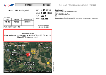


LF1657 - Condac
Located in Condac, France
ICAO - , IATA -
Data provided by AirmateGeneral information
Coordinates: N46°1'13" E0°14'33"
Elevation is 500 feet MSL.
View others Airports in Poitou-Charentes
Operational data
Special qualification required
Current time UTC:
Current local time:
Weather at : LFBU - Angouleme Brie Champniers ( 32 km )
METAR: LFBU 070530Z AUTO 25003KT 9000 FEW003/// BKN008/// BKN015/// ///CB 11/10 Q1017
TAF: TAF LFBU 070500Z 0706/0806 25005KT 9999 BKN015 TEMPO 0706/0710 3000 -SHRA BKN005 BKN020TCU PROB30 TEMPO 0706/0710 30015G25KT 1000 -TSRA BKN020CB FM071000 33010KT 9999 BKN025 TEMPO 0710/0716 3000 -SHRA BKN020TCU BECMG 0721/0724 VRB03KT BECMG 0800/0803 2000 BR BECMG 0803/0805 0800 FG VV/// TEMPO 0805/0806 0300
Communications frequencies: [VIEW]
Runways:
| RWY identifier | QFU | Length (ft) | Width (ft) | Surface | LDA (ft) |
| 18 | 0° | 918 | 52 | GRASS | |
| 36 | 0° | 918 | 52 | GRASS |
Airport contact information
Address: Condac France