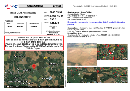


LF1655 - CHENOMMET
Located in Chenommet/Aunac-sur-Charente, France
ICAO - , IATA -
Data provided by AirmateGeneral information
Coordinates: N45°55'34" E0°15'41"
Elevation is 330 feet MSL.
View others Airports in Poitou-Charentes
Operational data
Special qualification required
Current time UTC:
Current local time:
Weather at : LFBU - Angouleme Brie Champniers ( 22 km )
METAR: LFBU 180330Z AUTO VRB02KT CAVOK 10/10 Q1011
TAF: TAF LFBU 171700Z 1718/1818 VRB03KT CAVOK TEMPO 1718/1720 4000 -SHRA BKN030TCU BECMG 1720/1722 3000 BR TEMPO 1800/1807 0800 FG VV/// BECMG 1808/1810 BKN030 TEMPO 1810/1818 4000 SHRA BKN015 BKN030TCU
Communications frequencies: [VIEW]
Runways:
| RWY identifier | QFU | Length (ft) | Width (ft) | Surface | LDA (ft) |
| 13 | 0° | 820 | 59 | GRASS | |
| 31 | 0° | 820 | 59 | GRASS |
Airport contact information
Address: Chenommet/Aunac-sur-Charente France
Web: www.autogire16.com