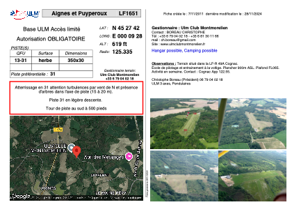


LF1651 - Aignes et Puyperoux
Located in Voeuil Et Giget, France
ICAO - , IATA -
Data provided by AirmateGeneral information
Coordinates: N45°27'42" E0°9'28"
Elevation is 619 feet MSL.
View others Airports in Aquitaine
Operational data
Special qualification required
Current time UTC:
Current local time:
Weather at : LFBU - Angouleme Brie Champniers ( 30 km )
METAR: LFBU 111700Z AUTO VRB02KT CAVOK 28/09 Q1014 NOSIG
TAF: TAF LFBU 111700Z 1118/1218 VRB02KT CAVOK BECMG 1120/1122 23010KT TEMPO 1122/1124 SCT050CB TEMPO 1200/1210 4000 SHRA BKN010 BKN040TCU
Communications frequencies: [VIEW]
Runways:
| RWY identifier | QFU | Length (ft) | Width (ft) | Surface | LDA (ft) |
| 13 | 0° | 1148 | 98 | GRASS | |
| 31 | 0° | 1148 | 98 | GRASS |
Airport contact information
Address: Voeuil Et Giget France