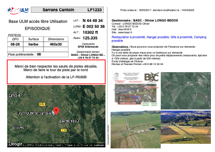


LF1233 - Sarrans Cantoin
Located in Cantoin-Aubrac, France
ICAO - , IATA -
Data provided by AirmateGeneral information
Coordinates: N44°49'34" E2°50'36"
Elevation is 10302 feet MSL.
View others Airports in Auvergne
Operational data
Special qualification required
Current time UTC:
Current local time:
Weather at : LFLW - Aurillac ( 35 km )
METAR: LFLW 291730Z AUTO VRB02KT 9999 OVC003 12/11 Q1018 TEMPO 2000 DZ
TAF: TAF AMD LFLW 291601Z 2916/2924 VRB02KT 9999 BKN045 BECMG 2916/2918 OVC009 TEMPO 2916/2924 2000 DZ OVC004
Communications frequencies: [VIEW]
Runways:
| RWY identifier | QFU | Length (ft) | Width (ft) | Surface | LDA (ft) |
| 08 | 0° | 1509 | 98 | GRASS | |
| 26 | 0° | 1509 | 98 | GRASS |
Airport contact information
Address: Cantoin-Aubrac France
Web: www.basc.fr