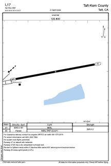


L17 - Taft-Kern County
Located in Taft, United States
ICAO - L17, IATA -
Data provided by AirmateGeneral information
Coordinates: N35°8'30" W119°26'16"
Elevation is 858 feet MSL.
Magnetic variation is 14° East View others Airports in California
Operational data
Special qualification required
Current time UTC:
Current local time:
Weather at : KBFL - Meadows Fld ( 47 km )
METAR: KBFL 262354Z 30008KT 10SM FEW055 FEW070 BKN100 20/07 A2988 RMK AO2 SLP116 T02000067 10228 20156 56029
TAF: KBFL 262320Z 2700/2724 32011G21KT P6SM SCT050 BKN100 FM270800 VRB06KT P6SM SCT050 BKN100 FM271900 31008KT P6SM SCT250
Communications frequencies: [VIEW]
Runways:
| RWY identifier | QFU | Length (ft) | Width (ft) | Surface | LDA (ft) |
| 07 | 80° | 3283 | 60 | ASPH | |
| 25 | 260° | 3283 | 60 | ASPH |
Airport contact information
Address: Taft United States