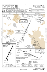
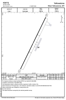


KWYS - Yellowstone
Located in West Yellowstone, United States
ICAO - WYS, IATA - WYS
Data provided by AirmateGeneral information
Coordinates: N44°41'18" W111°7'4"
Elevation is 6649 feet MSL.
Magnetic variation is 14° East View others Airports in Montana
Operational data
Special qualification required
Current time UTC:
Current local time:
Weather
METAR: KWYS 131715Z AUTO 24006G11KT 10SM FEW060 SCT070 BKN090 16/01 A3001 RMK AO2
TAF: KWYS 131120Z 1312/1412 VRB03KT P6SM SCT100 FM131700 VRB06KT P6SM BKN100 FM132000 24010KT P6SM VCSH BKN100 FM132300 21009KT 6SM SHRA BR BKN090 PROB30 1323/1405 4SM TSRA BR OVC050CB FM140500 VRB05KT P6SM BKN060
Communications frequencies: [VIEW]
Runways:
| RWY identifier | QFU | Length (ft) | Width (ft) | Surface | LDA (ft) |
| 01 | 26° | 8400 | 150 | ASPH | 8400 |
| 19 | 206° | 8400 | 150 | ASPH | 8400 |
Airport contact information
Address: West Yellowstone United States