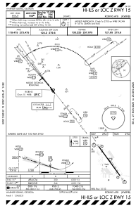
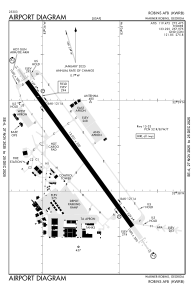


KWRB - Robins Afb
Located in Warner Robins, United States
ICAO - WRB, IATA - WRB
Data provided by AirmateGeneral information
Coordinates: N32°38'25" W83°35'31"
Elevation is 294 feet MSL.
Magnetic variation is -02° East View others Airports in Georgia
Operational data
Special qualification required
Current time UTC:
Current local time:
Weather
METAR: KWRB 160755Z AUTO 34005KT 10SM CLR 18/16 A2980 RMK AO2 SLPNO T01840160
TAF: TAF KWRB 160800Z 1608/1714 33009KT 9999 FEW045 QNH2980INS BECMG 1617/1618 30012G18KT 9999 FEW055 QNH2983INS BECMG 1701/1702 33006KT 9999 FEW045 QNH2982INS BECMG 1712/1713 18006KT 9000 -SHRA FEW025 BKN040 QNH2984INS TX30/1620Z TN17/1611Z
Communications frequencies: [VIEW]
Runways:
| RWY identifier | QFU | Length (ft) | Width (ft) | Surface | LDA (ft) |
| 15 | 144° | 12001 | 300 | OTHER | |
| 33 | 324° | 12001 | 300 | OTHER |
Airport contact information
Address: Warner Robins United States