


KWRB - Robins Afb
Located in Warner Robins, United States
ICAO - WRB, IATA - WRB
Data provided by AirmateGeneral information
Coordinates: N32°38'25" W83°35'31"
Elevation is 294 feet MSL.
Magnetic variation is -02° East View others Airports in Georgia
Operational data
Special qualification required
Current time UTC:
Current local time:
Weather
METAR: KWRB 291455Z AUTO 21009KT 10SM FEW032 24/14 A3017 RMK AO2 SLP217 T02420140 53002
TAF: TAF KWRB 290800Z 2908/3014 16007KT 9999 FEW100 SCT150 QNH3012INS BECMG 2913/2914 16010G15KT 9999 SCT080 QNH3013INS BECMG 2915/2916 17010G20KT 9999 SCT060 QNH3011INS BECMG 2919/2920 17010G15KT 9999 SCT050 QNH3008INS BECMG 2921/2922 16012KT 9999 SCT040 QNH3005INS BECMG 3006/3007 16003KT 8000 BR BKN030 QNH3001INS TX28/2920Z TN14/2911Z
Communications frequencies: [VIEW]
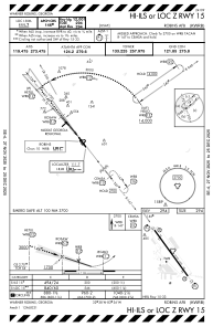
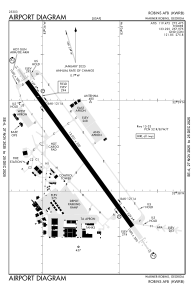
Runways:
| RWY identifier | QFU | Length (ft) | Width (ft) | Surface | LDA (ft) |
| 15 | 144° | 12001 | 300 | OTHER | |
| 33 | 324° | 12001 | 300 | OTHER |
Airport contact information
Address: Warner Robins United States