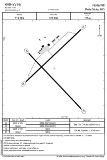


KVIH - Rolla Ntl
Located in Rolla/Vichy, United States
ICAO - VIH, IATA -
Data provided by AirmateGeneral information
Coordinates: N38°7'39" W91°46'10"
Elevation is 1148 feet MSL.
Magnetic variation is 02° East View others Airports in Missouri
Operational data
Special qualification required
Current time UTC:
Current local time:
Weather
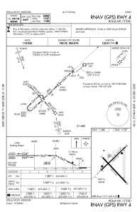
METAR: KVIH 101504Z AUTO VRB04KT 10SM FEW017 SCT025 SCT030 16/11 A3005 RMK AO2 T01610111
Communications frequencies: [VIEW]
Runways:
| RWY identifier | QFU | Length (ft) | Width (ft) | Surface | LDA (ft) |
| 04 | 47° | 5500 | 100 | ASPH | |
| 22 | 227° | 5500 | 100 | ASPH | |
| 13 | 137° | 5501 | 100 | ASPH | |
| 31 | 317° | 5501 | 100 | ASPH |
Airport contact information
Address: Rolla/Vichy United States