


KTXK - Texarkana Rgnl-Webb Fld
Located in Texarkana, United States
ICAO - TXK, IATA - TXK
Data provided by AirmateGeneral information
Coordinates: N33°27'13" W93°59'28"
Elevation is 389 feet MSL.
Magnetic variation is 05° East View others Airports in Arkansas
Operational data
Special qualification required
Current time UTC:
Current local time:
Weather
METAR: KTXK 140053Z AUTO 20003KT 8SM FEW008 23/20 A2969 RMK AO2 SLP050 T02280200
TAF: KTXK 132333Z 1400/1424 19005KT P6SM VCSH SCT025 BKN040 OVC060 FM140600 24005KT P6SM SCT025 BKN050 BKN150 FM140800 27008KT 6SM BR SKC FM141200 27006KT P6SM SCT250 FM141500 28010KT P6SM SCT020 FM141800 29012G20KT P6SM FEW030
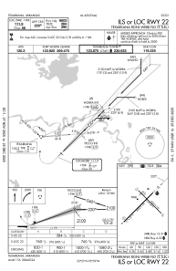
Communications frequencies: [VIEW]
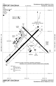
Runways:
| RWY identifier | QFU | Length (ft) | Width (ft) | Surface | LDA (ft) |
| 04 | 45° | 6602 | 150 | ASPH | 6602 |
| 22 | 225° | 6602 | 150 | ASPH | 6602 |
| 13 | 135° | 5200 | 100 | ASPH | 4559 |
| 31 | 315° | 5200 | 100 | ASPH | 4559 |
Airport contact information
Address: Texarkana United States
