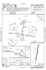
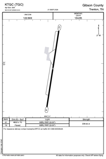


KTGC - Gibson County
Located in Trenton, United States
ICAO - TGC, IATA -
Data provided by AirmateGeneral information
Coordinates: N35°55'57" W88°50'56"
Elevation is 358 feet MSL.
Magnetic variation is -02° East View others Airports in Tennessee
Operational data
Special qualification required
Current time UTC:
Current local time:
Weather at : KMKL - Mc Kellar-Sipes Rgnl ( 37 km )
METAR: KMKL 061853Z 24010G16KT 10SM SCT029 SCT035 28/22 A2990 RMK AO2 SLP119 T02830217
TAF: KMKL 061734Z 0618/0718 22010G17KT P6SM SCT030 FM061900 21010KT P6SM VCTS SCT035CB BKN040 FM062300 18005KT P6SM BKN100 FM071300 20012G20KT P6SM BKN025 PROB30 0713/0717 5SM -SHRA BKN015
Communications frequencies: [VIEW]
Runways:
| RWY identifier | QFU | Length (ft) | Width (ft) | Surface | LDA (ft) |
| 01 | 9° | 4802 | 75 | ASPH | |
| 19 | 189° | 4802 | 75 | ASPH |
Airport contact information
Address: Trenton United States