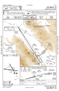
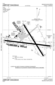


KSNS - Salinas Muni
Located in Salinas, United States
ICAO - SNS, IATA -
Data provided by AirmateGeneral information
Coordinates: N36°39'45" W121°36'26"
Elevation is 84 feet MSL.
Magnetic variation is 13° East View others Airports in California
Operational data
Special qualification required
Current time UTC:
Current local time:
Weather
METAR: KSNS 142353Z 32012KT 10SM CLR 16/10 A2989 RMK AO2 SLP131 T01610100 10178 20144 56010
TAF: KSNS 142334Z 1500/1524 31012KT P6SM SKC FM150300 32008KT P6SM OVC007 FM151700 34003KT P6SM OVC015 FM151900 32012KT P6SM SKC
Communications frequencies: [VIEW]
Runways:
| RWY identifier | QFU | Length (ft) | Width (ft) | Surface | LDA (ft) |
| 08 | 97° | 6004 | 150 | ASPH | |
| 26 | 277° | 6004 | 150 | ASPH | |
| 13 | 148° | 4825 | 150 | ASPH | |
| 31 | 328° | 4825 | 150 | ASPH |
Airport contact information
Address: Salinas United States
Other aviation service providers
Flight schools

Aerodynamic Aviation - Salinas
Aerodynamic Aviation - Salinas
info@aerodynamicaviation.com+1(831)240-0800