


KSKF - Kelly Fld
Located in San Antonio, United States
ICAO - SKF, IATA - SKF
Data provided by AirmateGeneral information
Coordinates: N29°23'3" W98°34'52"
Elevation is 690 feet MSL.
Magnetic variation is 04° East View others Airports in Texas
Operational data
Special qualification required
Current time UTC:
Current local time:
Weather
METAR: KSKF 210255Z AUTO 13014KT 10SM CLR 30/21 A2976 RMK AO2 SLP069 T02960207 53016 $
TAF: TAF KSKF 210200Z 2102/2208 13012G20KT 9999 SCT250 QNH2973INS TEMPO 2103/2105 13015G25KT BECMG 2105/2106 16009KT 8000 HZ BKN012 BKN250 QNH2975INS TEMPO 2108/2113 OVC008 BECMG 2114/2115 17010G15KT 9000 HZ BKN025 BKN250 QNH2977INS BECMG 2116/2117 16010G15KT 9999 NSW SCT045 SCT250 QNH2965INS BECMG 2201/2202 14012G22KT 9999 FEW050 BKN250 QNH2972INS TX36/2121Z TN24/2109Z
Communications frequencies: [VIEW]
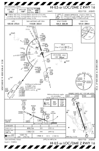
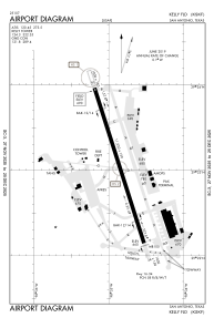
Runways:
| RWY identifier | QFU | Length (ft) | Width (ft) | Surface | LDA (ft) |
| 16 | 162° | 11550 | 150 | CONC | |
| 34 | 342° | 11550 | 150 | CONC |
Airport contact information
Address: San Antonio United States