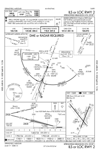
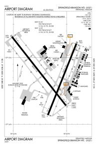


KSGF - Springfield-Branson Ntl
Located in Springfield, United States
ICAO - SGF, IATA - SGF
Data provided by AirmateGeneral information
Coordinates: N37°14'44" W93°23'19"
Elevation is 1268 feet MSL.
Magnetic variation is 03° East View others Airports in Missouri
Operational data
Special qualification required
Current time UTC:
Current local time:
Weather
METAR: KSGF 111852Z 32009KT 10SM CLR 24/07 A2999 RMK AO2 SLP149 T02390067 $
TAF: KSGF 111725Z 1118/1218 36006KT P6SM SKC FM120100 VRB03KT P6SM FEW250 FM121500 18009KT P6SM FEW240
Communications frequencies: [VIEW]
Runways:
| RWY identifier | QFU | Length (ft) | Width (ft) | Surface | LDA (ft) |
| 02 | 22° | 7003 | 150 | CONC | 7003 |
| 20 | 202° | 7003 | 150 | CONC | 7003 |
| 14 | 142° | 8000 | 150 | CONC | 8000 |
| 32 | 322° | 8000 | 150 | CONC | 8000 |
Airport contact information
Address: Springfield United States

