


KRIV - March Arb
Located in Riverside, United States
ICAO - RIV, IATA -
Data provided by AirmateGeneral information
Coordinates: N33°52'55" W117°15'32"
Elevation is 1536 feet MSL.
Magnetic variation is 14° East View others Airports in California
Operational data
Special qualification required
Current time UTC:
Current local time:
Weather
METAR: KRIV 171155Z 00000KT 7SM BKN008 OVC013 14/12 A2996 RMK AO2A SLP137 T01350121 10139 20129 57006 PWINO $
TAF: TAF KRIV 171205Z 1712/1818 VRB04KT 9999 BKN008 OVC013 QNH2995INS BECMG 1713/1714 VRB04KT 9999 NSW SCT010 BKN013 QNH2996INS BECMG 1717/1718 30005KT 9999 SCT015 QNH2994INS BECMG 1719/1720 31009KT 9999 FEW090 QNH2988INS TEMPO 1721/1801 32010G15KT BECMG 1802/1803 30006KT 9999 SKC QNH2990INS BECMG 1807/1808 VRB04KT 9999 OVC010 QNH2994INS BECMG 1809/1810 VRB04KT 9999 OVC007 QNH2994INS BECMG 1813/1814 VRB04KT 9999 BKN010 QNH2997INS BECMG 1815/1816 VRB04KT 9999 SCT015 QNH2999INS TX24/1722Z TN12/1713Z
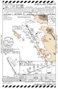
Communications frequencies: [VIEW]
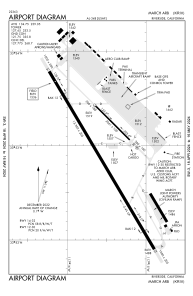
Runways:
| RWY identifier | QFU | Length (ft) | Width (ft) | Surface | LDA (ft) |
| 12 | 135° | 3061 | 100 | ASPH | |
| 30 | 315° | 3061 | 100 | ASPH | |
| 14 | 149° | 13302 | 200 | CONC | |
| 32 | 329° | 13302 | 200 | CONC |
Airport contact information
Address: Riverside United States