


KPVD - Rhode Island Tf Green Intl
Located in Providence, United States
ICAO - PVD, IATA - PVD
Data provided by AirmateGeneral information
Coordinates: N41°43'20" W71°25'40"
Elevation is 54 feet MSL.
Magnetic variation is -15° East View others Airports in Rhode Island
Operational data
Special qualification required
Current time UTC:
Current local time:
Weather
METAR: KPVD 111551Z 05010KT 10SM SCT040 BKN050 BKN060 12/04 A2986 RMK AO2 SLP111 T01220044
TAF: KPVD 111502Z 1115/1212 04011G20KT P6SM BKN040 FM120000 08006KT P6SM SCT150
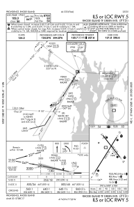
Communications frequencies: [VIEW]
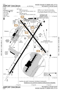
Runways:
| RWY identifier | QFU | Length (ft) | Width (ft) | Surface | LDA (ft) |
| 05 | 32° | 8700 | 150 | ASPH | 8700 |
| 23 | 212° | 8700 | 150 | ASPH | 8700 |
| 16 | 142° | 6081 | 150 | ASPH | 5516 |
| 34 | 322° | 6081 | 150 | ASPH | 6081 |
Airport contact information
Address: Providence United States

