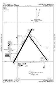


KPRB - Paso Robles Muni
Located in Paso Robles, United States
ICAO - PRB, IATA -
Data provided by AirmateGeneral information
Coordinates: N35°40'22" W120°37'37"
Elevation is 838 feet MSL.
Magnetic variation is 15° East View others Airports in California
Operational data
Special qualification required
Current time UTC:
Current local time:
Weather
METAR: KPRB 160153Z AUTO 20019KT 10SM CLR 17/11 A2983 RMK AO2 SLP097 T01720106
TAF: KPRB 152338Z 1600/1624 20015KT P6SM SKC FM160400 21008KT P6SM SKC FM160700 VRB03KT P6SM SKC FM161100 VRB03KT 1SM BR OVC003 FM161700 VRB03KT P6SM SKC FM162000 21010KT P6SM SKC FM162200 20020KT P6SM SKC
Communications frequencies: [VIEW]
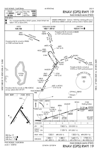
Runways:
| RWY identifier | QFU | Length (ft) | Width (ft) | Surface | LDA (ft) |
| 01 | 29° | 6008 | 150 | ASPH | |
| 19 | 209° | 6008 | 150 | ASPH | |
| 13 | 144° | 4701 | 100 | ASPH | |
| 31 | 324° | 4701 | 100 | ASPH |
Airport contact information
Address: Paso Robles United States

