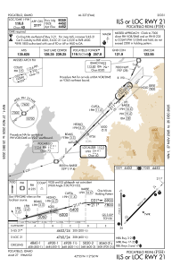
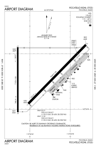


KPIH - Pocatello Rgnl
Located in Pocatello, United States
ICAO - PIH, IATA - PIH
Data provided by AirmateGeneral information
Coordinates: N42°54'35" W112°35'45"
Elevation is 4451 feet MSL.
Magnetic variation is 14° East View others Airports in Idaho
Operational data
Special qualification required
Current time UTC:
Current local time:
Weather
METAR: KPIH 091953Z 06017G26KT 10SM BKN050 18/01 A3018 RMK AO2 PK WND 03028/1900 SLP199 T01830011
TAF: KPIH 091726Z 0918/1018 04014G24KT P6SM FEW050 FM092100 04013G23KT P6SM VCTS SCT060CB FM100200 03007KT P6SM SKC
Communications frequencies: [VIEW]
Runways:
| RWY identifier | QFU | Length (ft) | Width (ft) | Surface | LDA (ft) |
| 03 | 45° | 9059 | 150 | ASPH | 9059 |
| 21 | 225° | 9059 | 150 | ASPH | 9059 |
| 17 | 180° | 7150 | 100 | ASPH | 7150 |
| 35 | 360° | 7150 | 100 | ASPH | 7150 |
Airport contact information
Address: Pocatello United States
