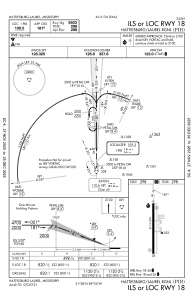
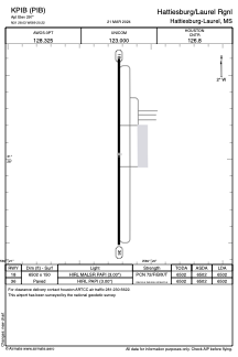


KPIB - Hattiesburg/Laurel Rgnl
Located in Hattiesburg-Laurel, United States
ICAO - PIB, IATA - PIB
Data provided by AirmateGeneral information
Coordinates: N31°28'2" W89°20'13"
Elevation is 297 feet MSL.
Magnetic variation is -01° East View others Airports in Mississippi
Operational data
Special qualification required
Current time UTC:
Current local time:
Weather
METAR: KPIB 162156Z AUTO 12007KT 10SM CLR 30/19 A2980 RMK AO2 SLP088 T03000194 $
TAF: KPIB 161727Z 1618/1718 13005KT P6SM FEW050 SCT150 FM170800 13008KT 6SM SHRA BR VCTS SCT009CB BKN025 FM171200 15009KT 6SM -RA BR OVC050 TEMPO 1712/1713 6SM -TSRA BKN050CB
Communications frequencies: [VIEW]
Runways:
| RWY identifier | QFU | Length (ft) | Width (ft) | Surface | LDA (ft) |
| 18 | 180° | 6502 | 150 | ASPH | 6502 |
| 36 | 360° | 6502 | 150 | ASPH | 6502 |
Airport contact information
Address: Hattiesburg-Laurel United States