


KPIA - General Downing - Peoria Intl
Located in Peoria, United States
ICAO - PIA, IATA - PIA
Data provided by AirmateGeneral information
Coordinates: N40°39'51" W89°41'36"
Elevation is 660 feet MSL.
Magnetic variation is -02° East View others Airports in Illinois
Operational data
Special qualification required
Current time UTC:
Current local time:
Weather
METAR: KPIA 161554Z 19008KT 10SM SCT039 SCT055 OVC080 20/17 A2986 RMK AO2 SLP108 T02000172
TAF: KPIA 161120Z 1612/1712 16005KT P6SM BKN090 FM161500 20008KT P6SM VCSH BKN070 FM161800 21010KT 6SM -SHRA BKN035 FM162100 22009KT P6SM BKN040 FM170700 VRB03KT 4SM BR BKN035 FM170900 VRB03KT 1 1/2SM BR SCT010
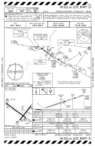
Communications frequencies: [VIEW]
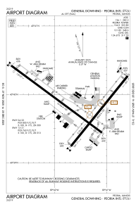
Runways:
| RWY identifier | QFU | Length (ft) | Width (ft) | Surface | LDA (ft) |
| 04 | 39° | 8004 | 150 | ASPH | 7826 |
| 22 | 219° | 8004 | 150 | ASPH | 8004 |
| 13 | 127° | 10104 | 150 | CONC | 9604 |
| 31 | 307° | 10104 | 150 | CONC | 10104 |
Airport contact information
Address: Peoria United States
