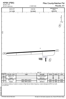


KPBX - Pike County/Hatcher Fld
Located in Pikeville, United States
ICAO - PBX, IATA -
Data provided by AirmateGeneral information
Coordinates: N37°33'43" W82°33'59"
Elevation is 1470 feet MSL.
Magnetic variation is -07° East View others Airports in Kentucky
Operational data
Special qualification required
Current time UTC:
Current local time:
Weather
METAR: KPBX 041035Z AUTO 00000KT 10SM SCT080 OVC100 18/18 A3002 RMK AO2 LTG DSNT SE T01840184
Communications frequencies: [VIEW]
Runways:
| RWY identifier | QFU | Length (ft) | Width (ft) | Surface | LDA (ft) |
| 02 | 16° | 3455 | 75 | ASPH | |
| 20 | 196° | 3455 | 75 | ASPH | |
| 09 | 87° | 5356 | 100 | ASPH | 4650 |
| 27 | 267° | 5356 | 100 | ASPH | 4650 |
Airport contact information
Address: Pikeville United States