


KOLF - L M Clayton
Located in Wolf Point, United States
ICAO - OLF, IATA - OLF
Data provided by AirmateGeneral information
Coordinates: N48°5'40" W105°34'30"
Elevation is 1988 feet MSL.
Magnetic variation is 09° East View others Airports in Montana
Operational data
Special qualification required
Current time UTC:
Current local time:
Weather
METAR: KOLF 272253Z AUTO 33011KT 10SM BKN110 23/05 A3002 RMK AO2 WSHFT 2153 SLP166 T02280050
TAF: KOLF 272322Z 2800/2824 33011KT P6SM BKN080 TEMPO 2800/2802 6SM -TSRA BKN040CB FM280200 VRB05KT P6SM SCT090 FM281500 12008KT P6SM SKC
Communications frequencies: [VIEW]
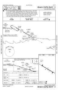
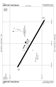
Runways:
| RWY identifier | QFU | Length (ft) | Width (ft) | Surface | LDA (ft) |
| 11 | 120° | 5091 | 100 | ASPH | |
| 29 | 300° | 5091 | 100 | ASPH |
Airport contact information
Address: Wolf Point United States