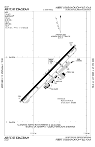


KOAJ - Albert J Ellis
Located in Jacksonville, United States
ICAO - OAJ, IATA - OAJ
Data provided by AirmateGeneral information
Coordinates: N34°49'45" W77°36'44"
Elevation is 92 feet MSL.
Magnetic variation is -08° East View others Airports in North Carolina
Operational data
Special qualification required
Current time UTC:
Current local time:
Weather
METAR: KOAJ 160649Z AUTO 35003KT 10SM FEW023 SCT032 18/18 A2970 RMK AO2 $
TAF: KOAJ 160608Z 1606/1706 VRB03KT 4SM BR OVC010 TEMPO 1608/1612 1SM BR OVC003 FM161300 36005KT P6SM BKN020 FM161400 35005KT P6SM SCT060 FM170100 00000KT P6SM FEW250 AMD LTD TO CLD VIS AND WIND
Communications frequencies: [VIEW]
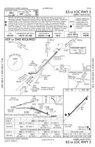
Runways:
| RWY identifier | QFU | Length (ft) | Width (ft) | Surface | LDA (ft) |
| 05 | 44° | 7100 | 150 | ASPH | |
| 23 | 224° | 7100 | 150 | ASPH |
Airport contact information
Address: Jacksonville United States